


Welcome

Engage With Us
Our master plan study for Milwaukee Mitchell International Airport has continued throughout the pandemic. But due to current health and safety concerns, we have determined that meeting virtually for this fourth and final Public Information Session is the best course of action to protect all involved in the process. We are glad you are here so that we can share our study progress and conclusions with you.

Introduction
Introduction
This virtual Public Information Session provides an overview of the planning that has occurred following the third open house meeting. Here you will find summaries of the important conclusions reached in a thorough exploration and evaluation of each proposed alternative plan for meeting the forecast demand at MKE over the upcoming two decades.
Explore Our Meeting
We have crafted this Public Information Session site to share information with you, allowing you to explore it at your own pace and to download graphics that you may want to review outside of this virtual meeting format. The stacked three lines in the upper right corner is a menu button which allows you to move among topics if you have a particular interest or are returning to the site with the intention of focusing on specific material. We are engaging with you in this virtual environment out of necessity given the challenges and uncertainties with convening in-person meetings.
Milwaukee County wants your feedback on the material available through this virtual Public Information Session. Your feedback will allow us to compile community input and subsequently update our project webpage to respond to areas of community interest or concern. Your online comment card is available by clicking the COMMENT box in the upper right corner at any time during your exploration of the meeting material.
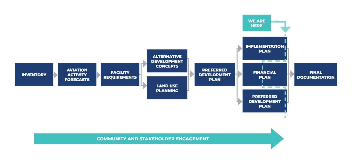
Sharing our planning work and conclusions is part of the master planning process, and the material we are making available through this Public Information Session summarizes the project efforts that have occurred since the third public open house was held in early 2020.
This Public Information Session sequentially summarizes planning efforts and intermediate conclusions as the initial development alternatives were screened and evaluated. It also identifies the Preferred Development Alternative that will serve as a framework for ongoing development planning over the long term.
Access to planning graphics:
- Some planning graphics can be downloaded at specific points on this website.
- Access to all downloadable documents may be requested using the DOWNLOAD MATERIALS form in the CONCLUSION section.
What Is A Master Plan?
A master plan study is an FAA-guided process that addresses the unique challenges and issues faced by the Airport while ensuring that there is a cohesive plan for meeting the aeronautical needs of the community over the next two decades. The MKE Master Plan conclusions are not a “development program” but rather a framework within which the County will make specific decisions regarding facility/physical and operational changes at MKE.
The MKE Master Plan also ensures that development aligns with regulatory and safety standards while remaining sensitive to community concerns.
Master plan materials presented at earlier public open houses are available through the project webpage.
What Is The Master Plan Process?
Master planning involves a sequential process in which information about the existing airport and its physical, operational, environmental, and financial characteristics is gathered and analyzed. It involves the preparation of a forecast of aeronautical activity, subject to review and approval by the Federal Aviation Administration (FAA), to project future aircraft, passenger, cargo, and general aviation activity. This aeronautical activity is the basis for determining the aeronautical facilities needed to meet the forecast demand in an operationally safe and efficient manner.
Alternative ways of meeting the defined aeronautical needs are explored and a future development plan is identified. The conclusions are documented and submitted to the FAA in the form of an Airport Layout Plan drawing set, with supporting documentation. Upon FAA approval, the Airport Layout Plan serves as the framework for future operational and development decisions at MKE, in response to demand and other triggers.
The planning process includes opportunities to share information with stakeholders, including the community, and to provide information/insights and obtain feedback in response to planning analyses and conclusions reached at interim milestones. Ultimately, the final FAA-approved Airport Layout Plan and supporting documentation becomes publicly available information.
This virtual Public Information Session is the fourth in the series of public engagement sessions. As we approach the conclusion of the master planning process, the information shared in this session presents the exploration of alternatives, culminating in the identification of the future long-range development concept for MKE. It also covers conclusions relating to the phased or incremental development that is projected to occur throughout the 2040 planning horizon, and presents an overview of the environmental and noise consequences of implementing the future concept.
The goal of the master plan is to provide the framework needed to guide future airport development that will cost effectively satisfy aviation demand, while considering potential environmental and socioeconomic impacts.
—FAA AC 150/5070-6B, Airport Master Plans
Alternatives Shortlisting Process
As was presented at the third MKE Master Plan open house, individual alternatives were developed for each of the six primary facility types:
- Airfield (including deicing facilities)
- Terminal
- Landside (including roadways, commercial vehicle access, curbside, parking, rental cars)
- Cargo
- General Aviation
- Support facilities
These alternatives were then screened to eliminate those deemed to contain significant deficiencies or challenges that limited their viability. The remaining alternatives were combined according to the hierarchy among the aeronautical facilities, and were adjusted to ensure each was physically and operationally feasible. This process yielded a total of six composite, or “integrated alternatives.”
The six integrated alternatives were evaluated during a workshop with MKE representatives with a focus on generating a shortlist of three alternatives that would undergo more intensive evaluation. Additionally, opportunities for potential refinement of each of the three shortlisted alternatives, with the objective of adjusting each where necessary, were identified.
Alternative 1 rightsizes the airfield to encompass three runways: 1L-19R, 7R-25L, and 13-31. Runways 1R-19L and 7L-25R are decommissioned.

Aircraft deice operations are centralized north of the terminal complex. A cargo campus is developed in the southeast quadrant of the airfield.
Aircraft maintenance facilities are consolidated in the area of the existing west cargo campus. Future general aviation facilities are consolidated in the northeast quadrant of the airfield.
Vehicle parking expands with a joint parking/rental car structure adjacent to the existing parking garage, coupled with expanded remote surface parking in the vicinity of Layton and Howell Avenues and in the vicinity of SuperSaver Lot B.
The airport access and circulation roads are modified to improve the safety and efficiency of vehicle movements.
In addition to the redevelopment of Concourse E, additional terminal expansion occurs northwest of existing Concourse C.
Alternative 2 rightsizes the airfield to encompass three runways: 1L-19R, 7R-25L, and 7L-25R. Runways 1R-19L and 13-31 are decommissioned.

Aircraft deice operations are centralized at the south end of the airport adjacent to the MKE Regional Business Park. A cargo campus is developed in the southeast quadrant of the airfield.
Aircraft maintenance facilities are developed in the western portion of the business park. Future general aviation facilities are consolidated in two campuses in the northern portion of the airport.
Vehicle parking expands with a joint parking/rental car structure adjacent to the existing parking garage, coupled with an additional parking structure south of the existing (expanded) joint use structure and with expanded remote surface parking in the vicinity of SuperSaver Lot B.
The airport access and circulation roads are modified to improve the safety and efficiency of vehicle movements.
Redeveloped Concourse E is planned for expansion to the west to accommodate gate expansion.
Alternative 3 rightsizes the airfield to encompass three runways: 1L-19R, 7R-25L, and 1R-19L (extended). Runways 7L-25R and 13-31 are decommissioned.

Aircraft deice operations are centralized in the vicinity or the existing terminal gate area. Dual cargo campuses emerge with an expansion of the existing west cargo area and development of a campus in a portion of the MKE Regional Business Park.
Aircraft maintenance facilities are consolidated in the northwest quadrant of the airport. Future general aviation facilities are consolidated in multiple campuses in the northern portion of the airport.
Vehicle parking expands in the terminal core area with a surface lot (or low-rise structure on the same site). Rental car facilities are consolidated and relocated to the vicinity of Layton and Howell Avenues freeing additional public parking capacity in the existing garage.
The airport access and circulation roads are modified to improve the safety and efficiency of vehicle movements.
In addition to the redevelopment of Concourse E, additional terminal expansion occurs northwest of existing Concourse C.
Alternative 4 rightsizes the airfield to encompass three runways: 1L-19R, 7R-25L, and 1R-19L (extended). Runways 7L-25R and 13-31 are decommissioned.

Aircraft deice operations are centralized in the vicinity of the existing terminal gate area. An expanded cargo campus emerges at the west end of the airport, requiring the acquisition of additional property south of Runway 7R-25L.
Aircraft maintenance facilities are consolidated in the northwest quadrant of the airport. Future general aviation facilities are developed in dual campuses along the east edge of the airport.
Vehicle parking expands with a joint parking/rental car structure south of the existing parking garage, coupled with expanded remote surface parking north of Layton Avenue.
The airport access and circulation roads are modified to improve the safety and efficiency of vehicle movements, expanding the area encompassed within the terminal roadway.
In addition to the redevelopment of Concourse E, additional terminal expansion occurs northwest of existing Concourse C.
Alternative 5A more modestly rightsizes the airfield to encompass four runways: 1L-19R, 1R-19L (extended), 7L-25R, and 7R-25L. Runway 13-31 is decommissioned, and Runway 7L-25R is shifted to the north to allow future accommodation of more operationally demanding aircraft.

Aircraft deice operations are centralized in the vicinity of the existing terminal gate area. MKE Regional Business Park is fully redeveloped to accommodate a consolidated cargo campus.
Dual aircraft maintenance campuses are developed in the area of Runway 7R and in the northeast quadrant of the airport. Future general aviation facilities are consolidated in the northwest quadrant of the airfield.
Vehicle parking expands in the terminal core area with expansion of the existing parking garage to the west and development of a surface lot south of the existing parking garage. Rental car facilities are consolidated and relocated to the vicinity of Layton and Howell Avenues freeing additional public parking capacity in the existing garage.
The airport access and circulation roads are modified to improve the safety and efficiency of vehicle movement.
A redeveloped Concourse E is planned for expansion to the west to accommodate gate expansion.
Alternative 5B more modestly rightsizes the airfield to encompass four runways: 1L-19R, 1R-19L (extended), 7L-25R, and 7R-25L. Runway 13-31 is decommissioned.

Aircraft deice operations are centralized in the vicinity of the existing terminal gate area. Dual cargo campuses emerge with an expansion of the existing west cargo area and development of a campus in a portion of the MKE Regional Business Park.
Aircraft maintenance facilities are developed in the western portion of the business park. Future general aviation facilities are consolidated in two campuses in the northern portion of the airport.
Vehicle parking expands with a joint parking/rental car structure in the vicinity of Layton and Howell Avenues, coupled with the redevelopment of SuperSaver A Lot into a parking structure.
The airport access and circulation roads are minimally modified to improve the safety and efficiency of vehicle movement.
A redeveloped Concourse E is planned for expansion to the west to accommodate gate expansion in a finger pier configuration.

Initial Evaluation Criteria
The six integrated alternatives were initially evaluated in a workshop with MKE representatives that assessed the performance of each against 12 established criteria. This initial evaluation identified three shortlisted alternatives to carry forward for further and more detailed evaluation.
Click the icons below to see more detail about how we did our evaluation.
-

- Collateral Development Potential
- Ability of the concept to accommodate non-aeronautical, revenue-generating development on Airport-owned land that is not required to satisfy aviation demand
-

- Compatibility with Adjacent Land Uses
- Relative measure of the compatibility of the concept with adjacent and proximate land uses in the vicinity of the Airport
-

- Landside Wayfinding
- Relative measure of the complexity of wayfinding for Airport users considering arrival, departure, circulation, recirculation, and access decision points
-

- Facility Consolidation
- Relative measure of the effectiveness of the concept in consolidating similar facilities and operations in organized areas of the Airport, considering airside and landside activities associated with various facilities
-

- Sustainability
- Relative measure of the environmental, social, operational, and economic aspects and enhancements associated with the long-term development of the concept (focus on meeting present needs without compromising the ability to meet future needs)
-

- Land Acquisition Requirement
- Relative measure of the amount of additional land required to accommodate concept development
-

- Flexibility
- Efficiency of the concept at accommodating facility development that emerges differently from planned timing, location, size, or other without adversely impacting dependent or adjacent facilities or conceptual development
-

- Rightsizing
- Effectiveness of the concept in optimizing long-term facility development, balancing capacity with forecast aeronautical demand
-

- Relative Cost
- Measure of the comparative capital investment to implement the full concept (detailed cost estimates are developed in subsequent evaluation steps)
-

- Operational Efficiency
- Measure of the relative efficiency of activity and operations (airfield, terminal, landside, and supporting facilities) if the concept is fully implemented
-

- Implementation Complexity
- Measure of the relative complexity of project and full concept implementation considering project dependencies, required enabling projects, operational impacts during construction, and related concerns
-

- Long-term Expandability
- Ability of the concept to efficiently and effectively accommodate demand-driven development beyond the 2040 planning horizon, maintaining a balance among airfield, terminal, and landside facility capacities
Results
The assessed performance of the six integrated alternatives is documented in a “stoplight chart” that characterizes the relative performance of each alternative. The alternatives that carry a concentration of “green” are determined to be the highest performing, while those that carry a concentration of “red” are determined to be the lowest performing, or have the most weaknesses.
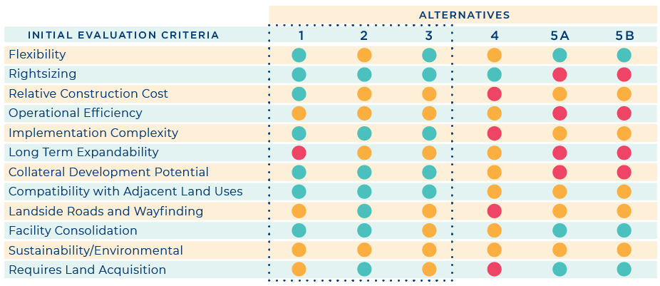
In this step of the alternatives analysis, Alternative 1, Alternative 2, and Alternative 3 were identified as the strongest among the six evaluated alternatives. Although these alternatives were evaluated as the best performing based on the twelve criteria used to shortlist, the process included a recognition that various refinements could ultimately improve each concept before being evaluated in more detail. The three shortlisted alternatives were subsequently renamed as Alternative A, Alternative B, and Alternative C, respectively, in preparation for a more in-depth evaluation.
Shortlisted Alternatives Evaluation
As part of a more detailed evaluation of the shortlisted alternatives, each was initially assessed on how well it aligned with the eight established MKE Master Plan goals. Although the three shortlisted alternatives each met the eight goals, certain alternatives aligned better with specific goals than others. The purpose of the goal assessment was not to select a preferred alternative, but rather to gather insight into whether there would be an opportunity for the Preferred Development Alternative, once selected, to be adjusted or refined considering these goals.
In addition to evaluating each alternative against defined evaluation criteria, the assessment included a waterfall analysis in which each major component (airfield, terminal, landside, cargo, general aviation, and support facilities) was assessed to identify downstream consequences based on the performance of each component. The waterfall analysis followed the defined hierarchy of facilities, starting with airfield elements.
Considering the evaluation results, the waterfall analysis specifically confirmed the components of the shortlisted alternatives. In this manner, opportunities to refine elements of the Preferred Development Alternative to improve its overall performance were identified.
The evaluation of the shortlisted alternatives included a workshop with airport representatives to review the above analysis and reach consensus on the selection of the Preferred Development Alternative.
Alternative A rightsizes the airfield to encompass three runways: 1L-19R, 7R-25L, and 13-31. Runways 1R-19L and 7L-25R are decommissioned.

Aircraft deice operations are centralized north of the terminal complex, adjacent to Runway 13-31. A cargo campus is developed in the southeast quadrant of the airfield.
Aircraft maintenance facilities are consolidated in the area of the existing west cargo campus. Future general aviation facilities are consolidated in the northeast quadrant of the airfield.
Vehicle parking expands with a joint parking/rental car structure adjacent to the existing parking garage, coupled with expanded remote surface parking in the vicinity of Layton and Howell Avenues, and in the vicinity of SuperSaver Lot B.
Airport access is relocated to the south, including modification of the Airport Spur bridge, and circulation roads are modified to improve the safety and efficiency of vehicle movements.
In addition to the redevelopment of Concourse E, additional terminal expansion occurs northwest of existing Concourse C.
Alternative B rightsizes the airfield to encompass three runways: 1L-19R, 7R-25L, and 7L-25R. Runways 1R-19L and 13-31 are decommissioned.

Aircraft deice operations are centralized north of the terminal complex adjacent to the existing hold pad and ramp area on the northern edge of the airfield. A cargo campus is developed in the southeast quadrant of the airfield.
Aircraft maintenance facilities are developed in the western portion of the MKE Regional Business Park. Future general aviation facilities are distributed between two campuses in the northern portion of the airport.
Vehicle parking expands with a joint parking/rental car structure adjacent to the existing parking garage, coupled with an additional parking structure south of the relocated airport entrance roadway and with expanded remote surface parking in the vicinity of SuperSaver Lot B.
The airport access roadway is shifted to the south, and circulation roads are modified to improve the safety and efficiency of vehicle movement.
A redeveloped Concourse E is planned for expansion to the west to accommodate gate expansion.
Alternative C rightsizes the airfield to encompass three runways: 1L-19R, 7R-25L, and 1R-19L (extended). Runways 7L-25R and 13-31 are decommissioned.

Aircraft deice operations are centralized in the vicinity of the existing terminal gate area. Dual cargo campuses emerge with an expansion of the existing west cargo area and development of a campus in a portion of the MKE Regional Business Park.
Aircraft maintenance facilities are consolidated in the northwest quadrant of the airport. Future general aviation facilities are consolidated in two campuses in the northern portion of the airport.
Vehicle parking expands in the terminal core area with a surface lot south of the existing airport entrance road (or low-rise structure on the same site). Vehicle parking also encompasses expansion of the existing parking garage to the west. Rental car facilities are consolidated and relocated to a structure in the vicinity of Layton and Howell Avenues, freeing additional public parking capacity in the existing garage.
The airport access road is relocated to the south, and circulation roads are modified to improve the safety and efficiency of vehicle movement.
In addition to the redevelopment of Concourse E, additional terminal expansion occurs northwest of existing Concourse C.

Shortlisted Alternatives Evaluation Criteria
Evaluation matrices were developed for each of the component areas of the three alternatives to qualitatively evaluate the components and quantitatively measure performance in specific categories. By design, the evaluation criteria used in the matrices are increasingly specific as the screening and evaluation process progresses.
Click the icons below to see more detail about how we did our evaluation.
-

- Airfield
Removes Airfield Constraints – effectiveness in mitigating current operational constraint or noncompliant condition, reduces runway intersections, and does not increase runway crossings
Allows Aircraft Traffic Segregation (in operating configurations) – runway layout supports the segregation of general aviation, cargo, and commercial aircraft operations (allows enhanced capacity via runway mix index); layout fosters separation of activity with dissimilar operating characteristics
Improves Operational Flexibility/Redundancy (provides parallel runways) – concept supports multiple airfield operating configurations and use in varying weather conditions
Facilitates Increasing Long-term Runway Capacity (post-2040) – concept can accommodate ultimate expansion of airfield beyond the 2040 horizon, allowing for ultimate capacity enhancement
Developable Area Potential (relative to the existing terminal area) – airfield configuration allows ultimate expansion of terminal facilities beyond the 2040 horizon
Relative Cost to Construct – relative construction cost assessment
-

- Deice Pads
Efficient Taxi Capability During Winter Operations – concept minimizes inefficient, circuitous, or constrained taxi flows; concept accommodates bypass taxi capability
Proximity to Primary Departure Runway Ends in Winter Operations – deice pads are located within reasonable taxi distance to winter departure flows
Opportunity for Future Expansion; Additional Deice Positions – location allows for deicing apron to expand as additional demand arises
Impact to Existing Infrastructure – existing facilities require relocation to accommodate decide infrastructure
-

- Landside - Roadways
Implementation Complexity – measure of the relative complexity of project and full-concept implementation considering project dependencies, required enabling projects, operational impacts during construction, and related considerations
Impact to Airport Spur Bridges (single or multiple locations) – concept requires relocation or modification to non-County-owned assets, such as Department of Transportation bridge structures over Howell Avenue
Visibility to Terminal Core Area – enhancement to visibility of terminal core area upon entering airport roadway (wayfinding)
Segregates Traffic Based on Destination – concept supports separation and channelization of traffic based on destination (minimizing weave conflicts, dissimilar traffic, and related considerations)
Operational Impact of Construction – degree of operational impact during implementation of major concept elements
Benefits to Air Cargo Way Circulation – concept incorporates new traffic pattern or circulation in vicinity of Air Cargo Way
Relative Cost to Construct – relative construction cost assessment
-

- Landside - Curbside
Line-of-Sight and Wayfinding – concept improves line-of-sight to terminal, parking, and/or rental car functions
Increases Volume of Curbside Traffic – concept creates an increase in curbside traffic from varying access modes
Flexibility to Expand Beyond 2040 Horizon – concept can accommodate additional capacity enhancements beyond the 2040 horizon
Encompasses Ground Transportation Center Capable of Handling Varied Modes – concept encompasses a ground transportation center (accommodates varying modes such as taxi cabs, limos, transportation network companies)
-

- Landside - Parking
Remote Public Parking – public parking areas located outside the terminal core area
Impacts to Walking Distances (close-in parking) – relative increase in parking passenger walking distance
Requires Shuttles (future parking areas) – parking shuttle required to support vehicle parking areas
Relative Cost to Construct (structure vs. surface) – relative cost to construct parking infrastructure
Construction Complexity – relative complexity of implementation and impacts to adjacent areas
Accommodates New Exit Plaza for Parking Garage to Meter Traffic Flow onto Exit Roadway – accommodates changes in parking structure exit to meter traffic flow onto Airport exit roadway
-

- Rental Car
Requires Shuttle – proximity of rental car facilities to terminal core area
Construction Complexity – concept can accommodate additional capacity enhancements beyond the 2040 horizon
Expansion Capability – concept can accommodate additional rental car expansion beyond the 2040 planning horizon
Passenger Experience – concept improves passenger journey or convenience
-

- Terminal
Expandability Beyond 2040 – concept accommodates expansion of terminal area beyond the 2040 planning horizon
Requires Relocation of Existing Gate – concept impacts existing gate locations or capability
Construction Complexity -–relative complexity of implementation and impacts to adjacent areas
Impact to MKE Administration Space – impact to County administrative space (Concourse C base)
Location of Remain Overnight – Remain Overnight operation proximity to terminal area
Expandability of Check-in/Bag Claim – ability for check-in and baggage claim facilities to be expanded beyond 2040 horizon as demand changes
-

- Cargo
Creates a Campus Environment (consolidation) – concept accommodates consolidated campus for cargo activity
Impact to Existing Facilities – degree of impact to existing facilities
Efficient Taxi Connectivity to Most Cargo-capable Runways – ability to connect to main departure and arrival runways capable of handling cargo activity
Impact to Existing Facilities – degree of impact to existing facilities to accommodate future development
Compatibility with Roadway Network – impact to existing landside traffic flows and circulation
-

- Support - General Aviation
Creates a Campus Environment (consolidation) – concept accommodates consolidated campus for general aviation activity
Proximity to Existing Corporate Activity – concept allows for corporate aviation to be adjacent to similar activities and facilities
Access Locations – requires new landside access point
Allows for Expansion Beyond 2040 Need – concept can accommodate additional capacity enhancements beyond the 2040 horizon
Implementation Complexity – relative complexity of implementation, impacts to adjacent areas, project dependencies
-

- Support - Aircraft Maintenance
Creates a Campus Environment (consolidation) – concept accommodates consolidated campus for aircraft maintenance activity
Impact to Existing Facilities – degree of impact to existing facilities to accommodate future development
Proximity to GRE – relative distance to ground runup enclosure
Provides Space for Future Growth and/or Consolidation – land area available to expand beyond 2040 as demand changes
-

- Support - Airport Maintenance
Requires Land Transaction with Wisconsin Air National Guard – requires use of land currently owned by WI ANG
Relocates Highway Department Facilities – degree of relocation or displacement of County Highway Department facilities
Allows for Staging of Snow Removal Equipment off Taxiway – staging of snow removal equipment is accommodated in other than taxiway locations
Landside/Airside Split Accommodates Extended Perimeter Service Road – perimeter service road relocation accommodated to allow secure access for transiting vehicles
Consolidates Airport Maintenance Facilities – concept creates a campus-type environment keeping facilities located adjacent to existing facilities
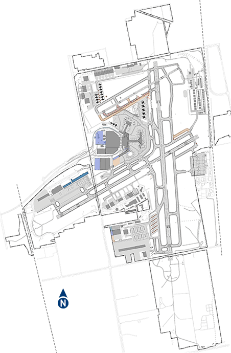
Preliminary Conclusion
During a workshop with MKE representatives, evaluation matrices were used to highlight the benefits and challenges of each alternative (overall and components), and to provide a quantitative measure of the performance of each compared to the other two. The matrix evaluation was supplemented by an exploration (waterfall analysis) of the consequences and opportunities associated with each. The result of this waterfall analysis was a cascading series of conclusions that ultimately supported the identification of the preliminary Preferred Development Alternative, including the refinements necessary to address specific challenges.
Alternative B emerged as the best performing future development alternative, with several refinements that incorporate elements of Alternative C.
Preferred Development Alternative
Once identified, refinements to the highest ranking (best performing) alternative were made to strengthen the operational, environmental, developmental, and financial aspects of the selected option. The refinements include adjustments to optimize operational efficiencies, support phased or incremental implementation, integrate master plan improvements with broader MKE capital improvements, and advance financial feasibility.
The primary components of the Preferred Development Alternative are presented below. To move through this content, scroll down. To return to any part of the plan already viewed, scroll up or click on the hamburger menu at the top right.
As you scroll down the page, a summary of the various improvements will appear. In addition to these improvements (components), there will be other incremental changes made during the implementation of the Preferred Development Alternative. The complete Preferred Development Alternative is documented in the Airport Layout Plan that will be submitted to the FAA for approval at the conclusion of the planning process.

 Airfield
Airfield
Airfield
Airfield
Airfield
Airfield
Airfield
Airfield
Airfield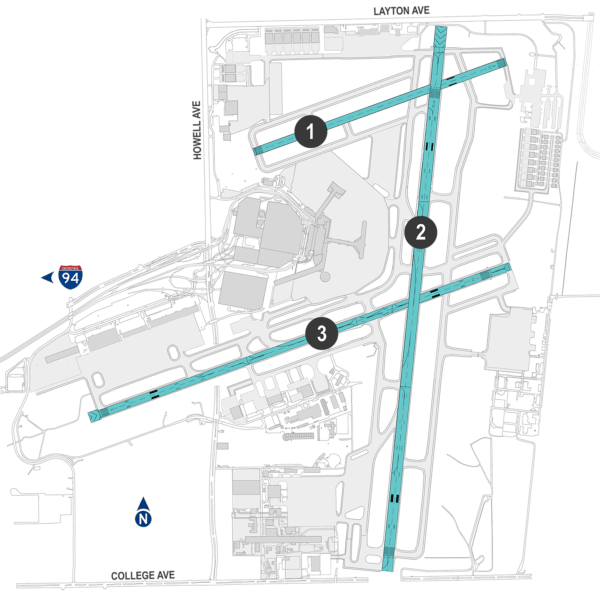 Airfield
Airfield
Airfield
Airfield
Airfield
Airfield
Airfield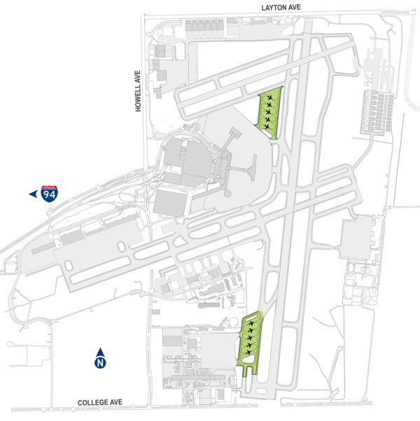
 Deice Pads
Deice Pads
Deice Pads
Deice Pads
Deice Pads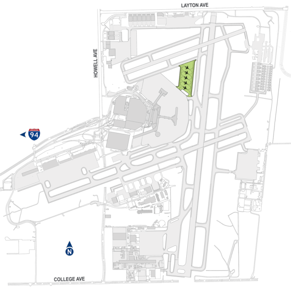 North Deice Pad
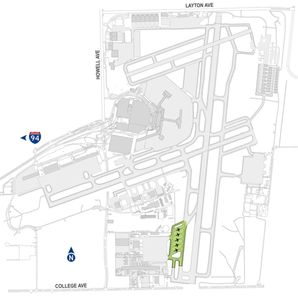 South Deice Pad
 Existing Terminal
Existing Terminal
Existing Terminal
Existing Terminal
Existing Terminal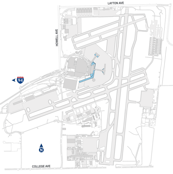 Terminal Expansion
Terminal Expansion
Terminal Expansion
Terminal Expansion
Terminal Expansion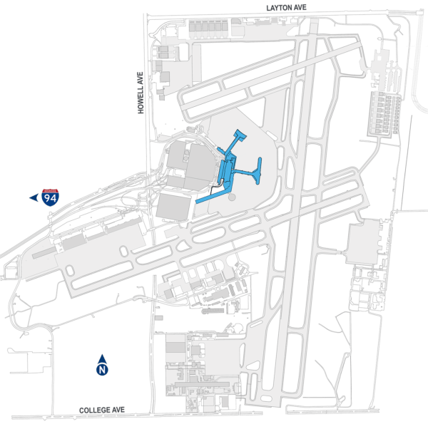 Terminal Modification
Terminal Modification
Terminal Modification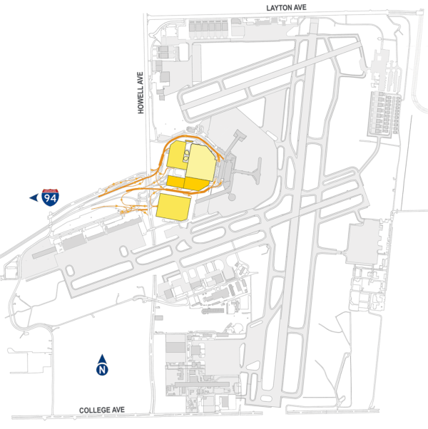
 Landside
Landside
Landside
Landside
Landside
Landside
Landside
Landside
Landside
Landside
Landside
Landside
Landside
Landside
Landside
Landside
Landside
Landside
Landside
Landside
Landside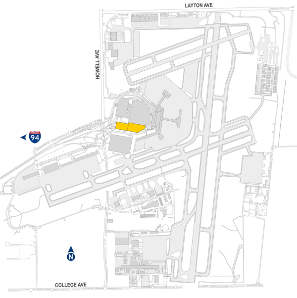
 Rental Car
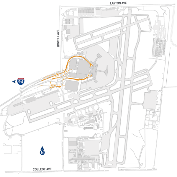
 Entrance Road
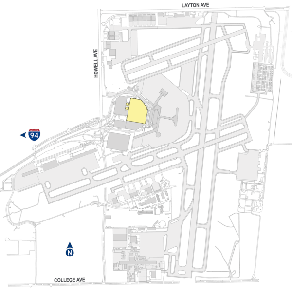
 Public Parking
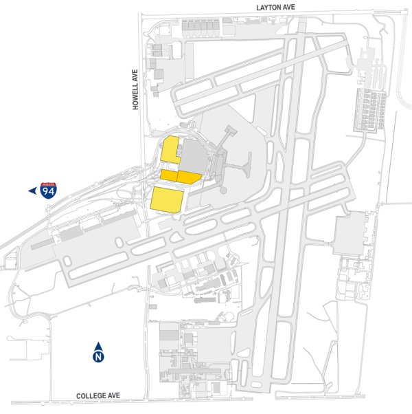 Parking Expansion
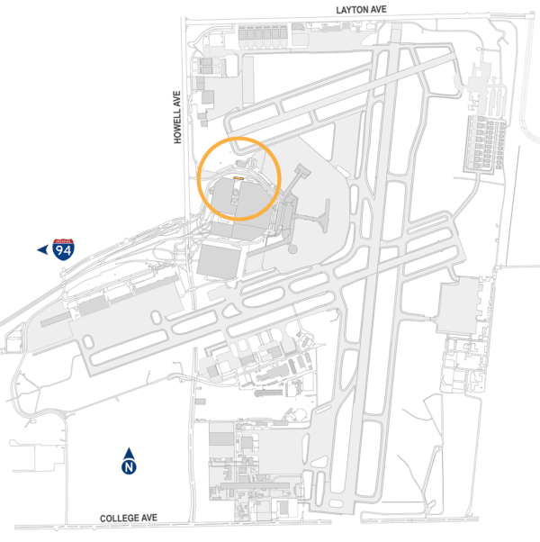 Public Parking Exit
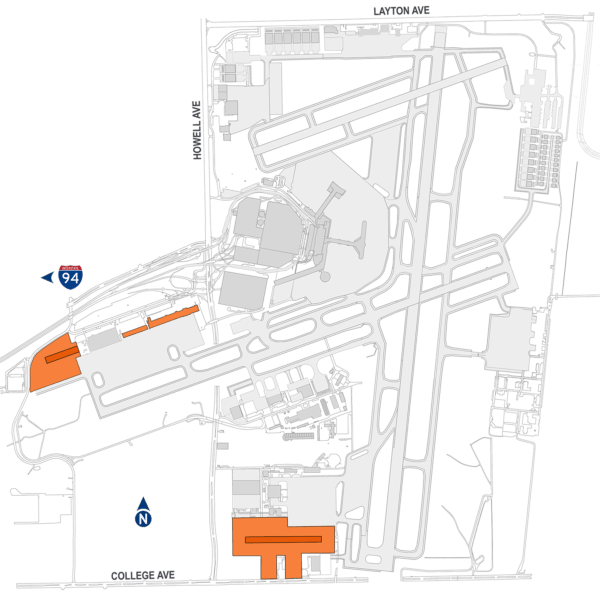
 Cargo
Cargo
Cargo
Cargo
Cargo
Cargo
Cargo
Cargo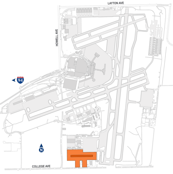
 South Cargo Addition
South Cargo Addition
South Cargo Addition
South Cargo Addition
South Cargo Addition
South Cargo Addition
South Cargo Addition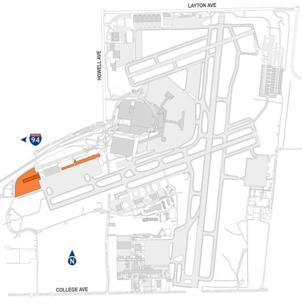
 Aircraft Maintenance
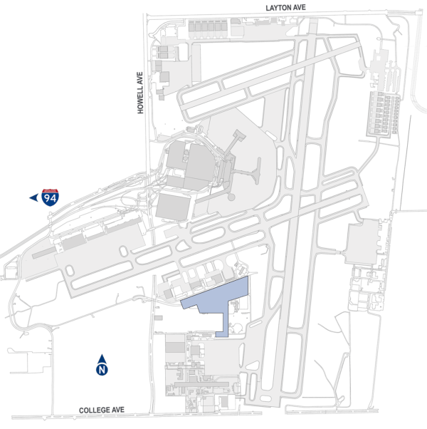
 Airport Maintenance
Airport Maintenance
Airport Maintenance
Airport Maintenance
Airport Maintenance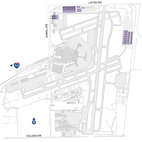
 General Aviation
The Future Is Bright
![]() Click and grab the airport map to get a closer look.
Click and grab the airport map to get a closer look.
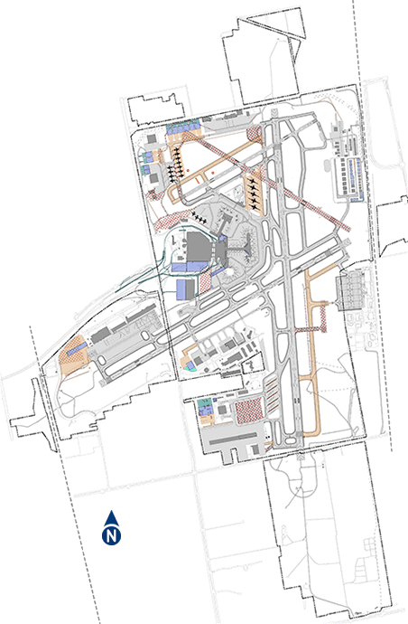
We have developed a long-range plan, focused on crafting a sustainable future for our community’s airport. That future includes a rightsizing of elements of MKE to secure its longevity, leveraging investments made in the airport while balancing the demands of maintaining and updating its facilities.
Our plan for MKE’s future provides an economic foundation for the area’s long-term growth. We continue to see increases in passengers, aircraft takeoffs and landings, and cargo, and our MKE Master Plan provides the roadmap for incremental improvements to accommodate that growth. Here are significant elements of our MKE Master Plan that we want to highlight.
Airfield
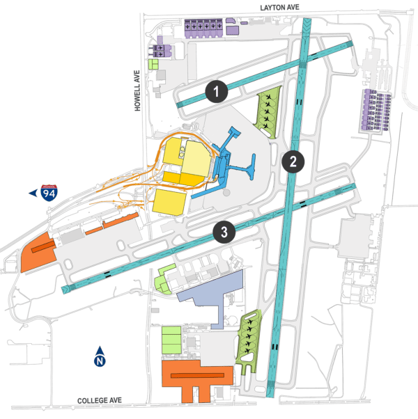
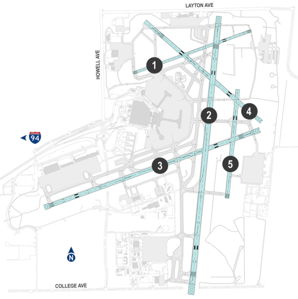
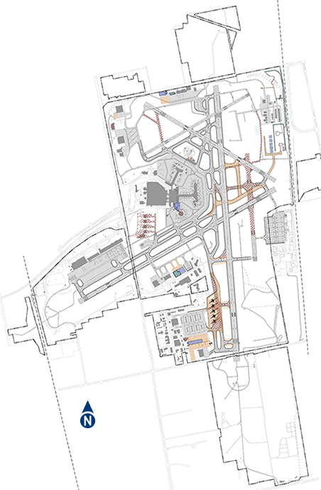
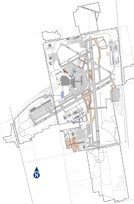
The airfield rightsizing will include the eventual decommissioning of two of MKE’s five runways (4 and 5 in diagram) to better conform with FAA standards, reduce long-term maintenance costs, and improve aircraft circulation.
Runway 7L-25R (1 in diagram) will be extended by 300 feet to improve utility for more operationally demanding general aviation aircraft.
Adjustments to the taxiway network will be made to efficiently support the three runways that remain in operation and to align with current FAA standards, which have changed since the original airport construction.
As MKE continues to experience growth in passengers, cargo, aircraft operations, and general aviation activity, an optimized and rightsized airfield will safely and efficiently accommodate these increasing demands.
Modifying the airfield to align with the size, type and frequency of aircraft arrivals and departures, and to support the efficient movement of aircraft as they taxi among airport facilities will cost effectively leverage existing airfield pavement while minimizing the operational and maintenance costs associated with airfield elements that are no longer necessary to meet demand.
Airfield
The rightsized airfield supports continued expansion of air service as airlines add destinations served from MKE and increase the frequency of scheduled flights, and new airlines initiate service at MKE.
The approach to optimizing the airfield ensures that County resources are prioritized among the multiple airport development, operational, and maintenance demands.
Changing industry standards, technology, and aircraft fleets influence the airfield changes at MKE.
Future taxiway network modifications will ensure that MKE’s airfield follows updated industry guidance, prioritizing the safe operation of aircraft.
Deice Pads
The future centralization of aircraft deicing will reduce congestion in the terminal gate area while also facilitating the management of deicing fluid runoff to promote environmental sustainability.
With two future deice pads, MKE will operate a total of three aircraft deicing pads, allowing reliable operation in nearly all weather conditions.
Two dedicated aircraft deicing pads are included to enhance safety during winter weather conditions and to manage the handling of aircraft deicing fluids more efficiently. During non-deicing conditions these pads will also be used to hold aircraft diverted to, or parked at, MKE overnight or for an extended duration.
North Deice Pad
The North Deice Pad location is adjusted to position the facility closer to the terminal core (gate) area for operational efficiency. The adjusted location also reduces the mixing of operationally dissimilar aircraft along Taxiway F.
South Deice Pad
The South Deice Pad integrates the use of the existing South Pad (formerly military apron) for aircraft deicing operations, preserving the opportunity for a future extension of Taxiway Q to provide dual taxi capability in the vicinity of Runway 1L.
Existing Terminal
The terminal complex improvements will include the reconfiguration of existing gates, passenger processing areas (for example, security screening checkpoints), and concession and passenger circulation corridors, as well as ultimate expansion of the number of gates.
Near-term Concourse E redevelopment plans bring the ability to process arriving international passengers into the terminal complex, functionally replacing the International Arrivals Building.
Eventually, this redeveloped concourse will incrementally expand in response to increasing passenger and airline demand.
Terminal Expansion
This future gate expansion ensures that a growing number of passengers will pass through the redeveloped concourse over the coming years.
We also plan to make changes within the existing terminal building to ensure that airlines can efficiently handle increasing numbers of passengers and baggage, and that new passenger security screening technologies can be implemented.
Our ultimate plan includes the connection of Concourse C, Concourse D, and Concourse E to allow passengers and employees to flow freely among gates and concessions once past security.
Terminal Modification
MKE continues to see growth in air service—both new airlines starting service, and new destinations and frequencies from our airport.
In addition to allowing the processing of arriving international passengers within the terminal building, our long-range redevelopment plan for Concourse E includes increasing its capacity by up to 10 airline gates.
Landside
MKE’s long-range plan for the landside environment (roadways, parking, rental cars, and commercial vehicles) will preserve the close-in and convenient experience that makes our airport unique.
By relocating the airport entrance road, additional space will be made available for expansion of parking and rental car facilities.
A new parking structure, ultimately including a pedestrian connection to the existing garage, will be constructed on the south side of the realigned entrance roadway, concentrating public parking in proximity to the terminal.
This new structure will also accommodate taxi and ride-share vehicle staging, ensuring short waits for arriving passengers.
The long-range landside changes will also include intersection improvements along Howell Avenue to ensure an efficient and safe operating environment as the number of airport-destined vehicles increases over the next two decades.
Likewise, the exit plaza from the existing parking garage will be relocated to provide additional distance for weaving and merging vehicles leaving the airport in any direction.
Maintaining Milwaukee County’s priorities of close-in and convenient vehicle parking and rental car operations, these features will occupy an expanded area in the terminal core to meet forecast demand.
This expansion will occur in proximity to existing parking facilities, close to the terminal. Improvements will include a consolidated rental car facility to provide an enhanced level of service to users and to improve the efficiency of rental car activities.
Roadway access to MKE will be modified to accommodate increasing vehicle activity and terminal area changes that will occur over the planning horizon.
The airport entrance road will be shifted to the south to make additional area available for expanded public parking and rental car operations.
Intersections along Howell Avenue will be improved to reflect changing vehicle patterns in the vicinity of the terminal complex.
Rental Car
Growth in rental car facilities will continue to be accommodated in the terminal core area by expanding the parking structure to the south and southwest.
Entrance Road
Alignment of the relocated Airport Spur entrance road is adjusted to minimize impact to the existing bridge structure, leveraging the existing infrastructure.
Public Parking
Expanding public parking will ensure the airport is able to meet public parking demand as maintenance or renewal of existing parking facilities is undertaken in the future.
Parking Expansion
Flexibility for future parking expansion is provided by preserving an area immediately west of the existing parking structure.
Public Parking Exit
The existing parking exit plaza is relocated to provide additional roadway merge distance and decision time as vehicles exit the Airport.
Cargo
Cargo growth has been robust at MKE including both traditional freight and e-commerce increases.
Cargo development will span two campuses—one is an expansion of the existing cargo area on the west side of the airport and a second that will include redevelopment of a portion of the MKE Regional Business Park.
Both campuses will have convenient roadway access to support the efficient transition of cargo between aircraft and ground vehicles.
As eCommerce and traditional cargo transport continues to grow, MKE will be able to efficiently meet forecast demand with dual cargo campuses located in proximity to the airport’s two longest runways.
South Cargo Addition
The MKE Regional Business Park redevelopment is adjusted to encompass a mix of cargo facilities and aircraft maintenance facilities to better optimize development in the southern portion of the airfield.
With limited expansion potential of MKE’s existing West Cargo Campus, a supplemental South Cargo Campus is included in our long-range plan.
This campus will occupy approximately half of the MKE Regional Business Park, redeveloping the existing business park facilities as the need for additional cargo buildings, aircraft apron, and truck and vehicle parking emerges.
The South Cargo Campus benefits from immediate aircraft access to the airport’s primary runway, and vehicle access from both Howell Avenue and College Avenue directly linking to Interstate-94.
 West Cargo Expansion
Future expansion of cargo facilities is concentrated in the southern portion of the airport by expanding the existing West Cargo campus, as triggered by demand, and leveraging existing infrastructure in this area.
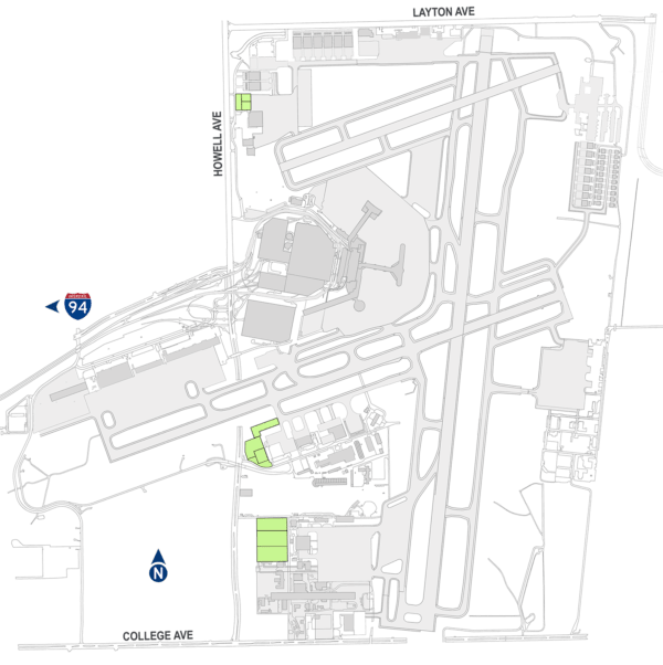
Aircraft Maintenance
Future maintenance facilities will be accommodated adjacent to similar existing facilities in the northwest quadrant of the airport, providing a secondary maintenance campus supporting corporate and business general aviation.
Airport Maintenance
As MKE changes and grows over time, so does the need for airport maintenance activities.
To house additional staff, equipment, and materials needed to maintain airport infrastructure and ensure a safe operating environment, the airport maintenance campus will need to be expanded and reconfigured.
The current airport maintenance facilities are centrally located on airport property and are planned for expansion and reconfiguration within the currently occupied area.
General Aviation
Additional general aviation facilities will be developed in the vicinity of the existing fixed base operator facilities in response to activity growth, consolidating general aviation in the northern portion of the airfield.
General aviation facilities will be largely consolidated in the northern portion of the airport, including a corporate/business general aviation (GA) campus in the northwest quadrant and a corporate/private GA campus in the northeast quadrant.
Vehicle access will be adjusted to reduce the encroachment on critical airfield surfaces and taxiway modifications will provide safe and efficient access to the two GA campuses.
This development will occur incrementally as MKE experiences growth in GA activity and GA tenant interest.
Given forecast growth in GA activity and the industry trend toward higher performing GA aircraft, our long-range plan concentrates GA facilities in the northern portion of the airport.
Consolidating the majority of GA development provides flexibility in the development of individual components and efficiencies associated with aggregating operationally similar aircraft facilities and operations.
Future GA development will include a range of tie-down ramps, hangars of varying sizes, and dedicated landside access for users and operators.
Some will be located along Layton Avenue in the northwest quadrant, while a larger portion will be located in an expansion of the existing GA campus in the northeast quadrant. The future of MKE is not only bright, but it is also sustainable.
Milwaukee County is focused on sustaining the future of our hometown airport—operationally, environmentally, and financially. Although our master plan maps future development, it preserves an intentional degree of flexibility so that we can confidently adjust to as-yet unidentified industry changes that could influence activity at MKE. We will ensure that our airport stays current with industry standards, technological changes, airline business models, and the evolution of the overall aircraft fleet operating here.
Environmental Considerations
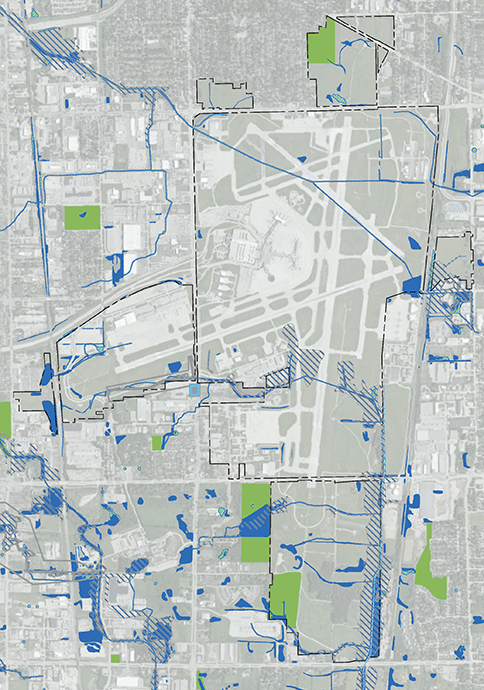
The planning process recognizes the presence of environmental features within the airport property, starting with an inventory of those resources during the early stages of the study. As alternative plans are conceptualized, the documented environmental resources are reviewed with the intention of minimizing adverse consequences. This is often accomplished through the modification or refinement of a concept, adjusting it to avoid or minimize impacts due to development.
Representative categories include:
- wetlands
- floodplains
- water quality
- threatened or endangered species
- incompatible land uses
- related environmental resources
The map of environmental conditions depicts various state- and federally regulated environmental features that were considered during the planning process. Although impacts to all features cannot be avoided, the preferred development concept minimizes them where possible. Closer to the time of implementation, future development actions at MKE will be subject to a detailed review of potential environmental impacts and mitigation of identified impacts where possible and required.
Noise Exposure Analysis
As aircraft activity increases at MKE over the next two decades, associated noise exposure is projected to increase. The MKE Master Plan evaluates the relative increase in noise, comparing the noise impacts of activity growth based on the existing airfield (“no action” alternative) and the noise impacts of that increased activity based on the reconfigured airfield (“with project” alternative). The FAA considers noise exposure of 65 decibels or greater to be significant. Based on FAA guidance, an increase of more than 1.5 decibels is considered to be significant.
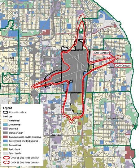
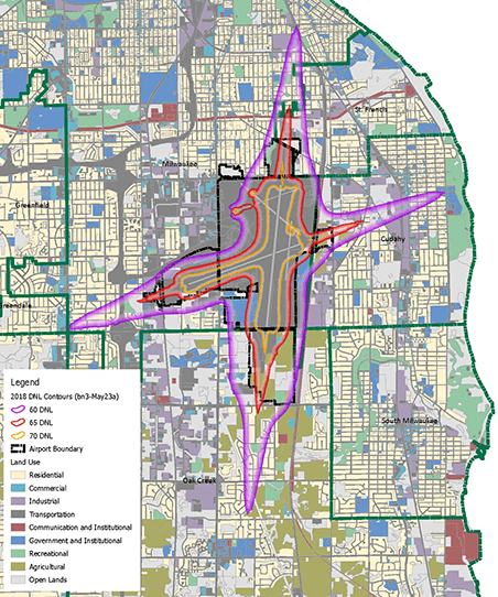
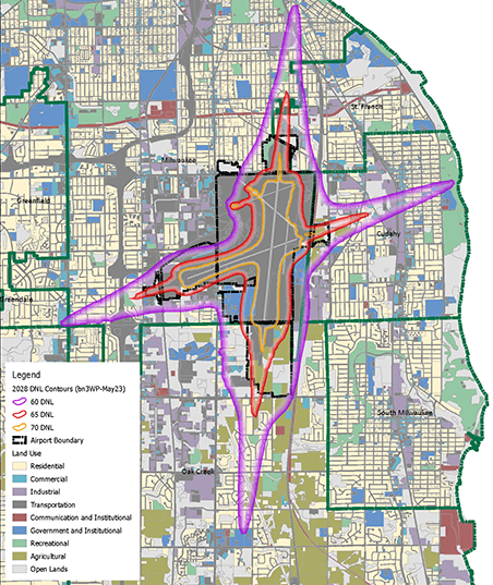
Since MKE’s Part 150 Noise Study was completed in 2009, there has been notable industry change relative to aircraft noise. Significantly, advancements in aircraft airframe and engine technology, evolution of the overall aircraft fleet, and air traffic changes have all reduced the noise footprint associated with aircraft operations at MKE. As a consequence, aircraft noise exposure in the vicinity of MKE is significantly less than was predicted and simulated in the Airport’s Part 150 Noise Study.
The noise contours show the noise exposure generated by modeling the FAA-approved forecast aircraft operations under existing (2018) baseline conditions and aircraft activity at the 10-year (2028) horizon. The resulting increase in noise exposure is determined to be less than the FAA-defined 1.5 decibel threshold of significance.
Phased Implementation
Physical and operational changes at MKE will be phased in over the long-range planning horizon, in response to demand (activity) or other triggers. A phased implementation of development projects ensures that the County will undertake improvements in a financially measured way. It also ensures that the County can continue to refine aspects of the Preferred Development Alternative in order to reflect changing industry standards, evolving airline business and operational models, modified demand and peaking characteristics, and similar influences. The Preferred Development Alternative has been defined with an intentional level of flexibility to accommodate change or more robust increases in activity without undermining the utility and advantages of the overall concept.
Development has been considered in four horizons:
- Years 1-5
- Years 6-10
- Years 11-22 (through 2040)
- Years 23+
This phased development is planned around facility changes necessary to accommodate the baseline forecast of activity. However, allowance is made for adjustments to accommodate activity growth that may differ in magnitude or characteristics if actual aeronautical activity should vary from the baseline forecast. The phased development will ultimately serve as the basis for preparing a 10-year Capital Improvement Program (CIP).
Because development actions will be taken in response to specific triggers, facility changes may ultimately occur in different timeframes, either sooner or later than depicted. User and tenant needs, as well as financial feasibility will also influence the future timing of specific projects. Similarly, these triggers may also influence the specific scope and configuration of future development.
Conclusion
We appreciate the time you’ve spent reviewing this virtual meeting site. Please take some time to provide your feedback using the comment button on this page. This is OUR community’s airport, and your input is valued as we balance our community’s needs and the future of aviation activity in southeast Wisconsin.
